Posts

Showing posts from April, 2018

Momma said, "There'll be days like this..." Wow!

Image
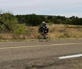
Day 9: Las Vegas, NM to Tucumcari, NM 109 miles for the day, 3357' up, 5676' down It was only 42 degrees when we woke up at 5:25, and maybe only a couple of degrees warmer when the guys started out at 6:15. by 7:00, it was up to 50 degrees and did not hit 70 until 10:22. The result was very favorable riding temperatures, compared with the heat of the first few days. The winds were absent as well for at least the first 47 miles, and then generally favorable until the last 10 miles into Tucumcari.  The guys around mile 15 The route today was entirely on Route 104, a lonesome highway with little traffic, and only one store/post office the entire way, at mile 76 in the "town" of Conchas. The route early on was  a lot of ups and downs, including one long, straight stretch down with very smooth new pavement where everyone topped 40 mph. Whee! They topped out about 1000 feet higher than where they started at  the top of the Las Vegas Plateau at about mile

Easy days to recharge batteries

Image
Day 9: Santa Fe, NM to Las Vegas, New Mexico, 70 easy miles (for me, especially) The guys got an early start again, and rode through the city of Santa Fe to get on Hwy. 25, and then started climbing.  Guys on the entry ramp to the freeway  I started soon after and went on past them, only to see that there was a stretch of freeway that went into a deep valley with guardrails about 30 inches away from the white line, and half of that 30 inches taken up by rumble strips. I sped to the next exit to double back to catch the guys to have them get off at Exit 290 (on the ABB cue sheet but we had thought we could disregard that instruction). They safely made the four mile detour and journeyed on along the freeway until Exit 339.  We did an impromptu SAG on the side of the freeway about 30 miles in and another about 45 miles.  Rick at Exit 325 Rest Stop Views along the way There had been quite a bit of climbing by then, but in temperatures that started in the hig

Plans aborted, plans changed

Image
Day 7 plan: Gallup, NM to Albuquerque, NM 136 miles for the day, 3093' up, 4626' down - Oops! Today was a day that did not go as planned. The riders were up and at 'em by 6:30, with a 146 mile day ahead. With that distance, the plan would be for me to ride in  some 20 mile stretches to give some of the guys a break so they would not need to ride the entire distance. I drove up to  the Continental Divide at 7245' which would be the 32 mile mark for them. It was steady climb starting at about 6312' elevation so the thin air was a factor, but what was worse was about a two mile stretch of awful shoulder along Hwy. 40 and the start of a stiff headwind.  Upon arrival, Ken said, "32 miles and almost 3 hours to get here. The arithmetic for the day doesn't work." Nonetheless, we began to try to work the plan by my taking off riding, with Vern in the truck. The route was supposed to be pretty much downhill from there until a big bump just before Albu

Flats, flats and more flats, and I am not talking about the terrain.

Image
Day 6: Winslow, AZ to Gallup, NM 123 miles for the day, 3815' up, 2097' down The team rode Interstate 40 all day today. My cell phone registered 47 degrees at 5:25, then rose to 61 by 8:00. So, the guys started with arm and leg warmers on, It only got to 82 degrees at 1:00. a big change from the days before.  Eric After leaving at 6:15, they immediately got on Hwy. 40E. The first stop was at Exit 277 at about mile 36 for a quick clothing adjustment and water stop, Then on to Exit 292 at about mile 69 for lunch. Then a long stretch to Exit 348 for a quick water break, then they pushed on to Gallup to finish the 123 miles at the Red Roof Inn. They rode by a whole lot of not much of anything. Yep, entered New Mexico by 16 miles. The theme today was flat tires. Ken had 2, Vern 1, Jerry 3, Eric and Phil zero. The tiny wires along the road from the steel belted radials really caused problems. Did I mention they got flats? The same photo? Yep. The guys didn

"Oh, What a Beautiful Morning, Oh, What a Beautiful Day"

Image
Day 5 - Cottonwood to Winslow, AZ (109 miles), 5712' up, 4172' down Breakfast again at 6:00 and on the road at 6:15. The road rose steadily, then continued through beautiful red rock country, through the towns of Sedona and Old Town Sedona until they reached Oak Creek Canyon.  Distance view of Sedona area Coming into Sedona Sedona red rocks Oak Creek Canyon ... ah....... It was only 59 degrees at 6:00 and had risen to 71 at 8:30 and back to 68 bu 11:00. I don't think it got above 76 all day, so was an excellent riding day. The ride up Oak Creek Canyon to the rest area/lookout point at the false "summit" at 6420' elevation was gorgeous, even if it was uphill. Jerry arrived first, and confidently declared, "I'm back!" The others arrived all in good shape, handling the last 2.6 miles of quite steep, winding road without difficulty. It was reassuring to see Ken fully back in stride as well, after some concern in the hot d

Cyclist Physics: What Goes Down, Must Go Up

Image
Day 4: Wickenburg to Cottonwood, AZ (102 miles), 8697' up', 7430' down Life has its ups and downs, and so did today. After a great 6:00 breakfast at the Best Western in Wickenburg, the guys started out at 6:15 in great 64 degree temperatures and beautiful blue skies.  They had a stiff climb to Yarnell Pass to reach the elevation of 4850'. Vern had his gears skipping so that he could not use his lowest two gears coming up the hill, so that made it all the more difficult. After a quick impromptu SAG at the top, they had a wonderful  ride down to Peoples Valley, then Skull Valley and then the road turned up again. It is demoralizing as the road looks flat, but your legs tell you different. I recall this slope looking flat in 2016 wearing me out. We had a SAG at mile 42.7 at a store in Wilhoit. Jerry was the last to arrive, suffering from intestinal pain and just not feeling well at all. He decided he needed to ride in the truck for awhile. If anyone has the idea that t

Day 3: There's Always Hope

Image
Today's ride featured freeways and more heat, but we saw Hope - the town, that is.... The day started at 64 degrees in Blythe at 5:45. After a short ride along a freeway frontage road they got on freeway Hwy, 10 and almost right away began climbing. Then they entered Arizona, one state down, several more to go. They were on Hwy. 10, a freeway, for 32 miles,  Their  first climb was to mile 16.5, then a small dip, then climb again to mile 34.5. Then they got off Hwy. 10, onto Hwy. 60, a two lane road that would take us all the way to our motel in Wickenburg. On Highway 60, we followed the two lane road on a steady uphill climb, from about 1200 feet elevation to about 2625' It never got steep, but it was a steady climb.  We had the first SAG at the Buckaroo Country Store in the town of Brenda. Brenda was pretty sleepy now, but apparently have about 1000 trailers parking around there in the winter. Shortly thereafter, we passed through the "town" of Hope